Messenger Newsletter Published

EuroGeographics has been proudly representing Europe’s National Mapping, Cadastral and Land Registration Authorities for 25 years.
The Association celebrating its silver jubilee however is very different to the one established at the turn of the Millennium. Today, we are recognised as the point of contact for advice, comment, and supply of European geospatial and land information from official national sources, not only in Europe, but also at global level through our partnership with the United Nations Statistical Division and UN-GGIM.
Anniversaries are a wonderful chance to celebrate success; they are also an unmissable opportunity to reflect on past achievements and use this experience to put in place solid plans for the future.
In this brochure commemorating 25 years of EuroGeographics, you’ll find insights and perspectives on the past, present and future of authoritative pan-European data from a wide range of commentators, all of whom have played a pivotal role in the Association becoming the well-respected and forward-looking organisation it is today.

Foto: Gatis Dieziņš (Aizsardzības ministrija)
Leaders from 47 European National Mapping, Cadastral and Land Registration Authorities met in Latvia recently to share insights on delivering authoritative data in increasingly uncertain times.
Hosted by the Latvian Geospatial Information Agency with support from the State Land Service, the EuroGeographics 2025 General Assembly was one of the biggest gatherings of geospatial experts in the not-for-profit Association’s 25-year history.
During the two-day event, members re-elected Tomaž Petek from Surveying and Mapping Authority of the Republic of Slovenia, as President and Suren Tovmasyan, Cadastre Committee of the Republic of Armenia, to the Management Board.
Welcoming delegates, Tomaž Petek said: “EuroGeographics is a remarkable example of what can be achieved through Europe-wide cooperation. The Association celebrating its silver jubilee however is very different to the one established at the turn of the Millennium. Today, we are recognised as the point of contact for advice, comment, and supply of European geospatial and land information from official national sources, not only in Europe, but also at global level through our partnership with the United Nations Statistical Division and UN Committee of Experts on Global Geospatial Information Management (UN-GGIM).”
“Bringing together, not only members’ collective expertise, but also their data across national boundaries is the Association’s primary strength and a powerful symbol of certainty and trust in a complex and uncertain world. We remain united by a common purpose to support the public good, and we have overcome many different challenges to ensure that official data is recognised as an essential component of national, European and global critical infrastructures.”
Sallie Payne Snell, Secretary General and Executive Director, EuroGeographics added: “Welcoming us to Riga, the Minister of Defence recognised that members have long been trusted sources of geospatial information but that today a modern mapping agency must be able to operate under conditions of uncertainty.”
“This week, we have demonstrated why their data can be trusted, why it can be relied upon, and why it is fundamental resource that enables us to look to the future with confidence and certainty in challenging and unpredictable times.”
“As we take our next steps together in realising our vision of a society empowered by the use of trusted geospatial services, our focus must be on enabling access to members’ high-value data and expertise through its integration into the infrastructures we depend upon as a modern society.”
EuroGeographics General Assembly coincided with the publication of the Association’s latest Annual Review which features case studies demonstrating how members fulfil an essential role ensuring fundamental information about location is available for confident, informed decision making. Examples include security, climate change and environmental monitoring to economic growth and prosperity.
Read EuroGeographics Annual Review.
EuroGeographics is an international not-for-profit organisation (AISBL/ IVZW under Belgian Law. BCE registration: 833 607 112) and the membership association for the European National Mapping, Cadastral and Land Registry Authorities.
Aligning the INSPIRE Directive with European Union horizontal legislation is highly valuable, but investments already made in the Directive’s implementation must be respected, says EuroGeographics.
In its response to the European Commission’s Public Consultation assessing the impact of the Green Data for All initiative, the Association for Europe’s National Mapping, Cadastral and Land Registration Authorities urged the streamlining of the Directive to reduce bureaucratic requirements and focus on solution-driven processes.
“The geodata infrastructure built over the past two decades has many useful applications but currently the management of the geospatial sector within the EU is fragmented and scattered across various Directives,” says Carol Agius, Head of Representation and Stakeholder Engagement, EuroGeographics.
“It would therefore be highly valuable to fully align INSPIRE with the EU’s horizontal legislation, such as the Open Data and Reuse of Public Sector Information, as well as the Implementing Act on High Value Data. However, we would urge the Commission to respect the significant investments our members have already made in implementing INSPIRE by incorporating their practical experience in any future plans.”
EuroGeographics also highlighted the importance of harmonising high-value datasets shared by national public sector bodies. However, it cautions that this is a delicate, sector specific process requiring in-depth knowledge and should only be undertaken by experts.
“Our members are experts in harmonising and edge-matching national geospatial data to create pan-European datasets, most recently to create a high-value large-scale prototype through the Open Maps for Europe 2 (OME2) Project. By the end of 2025, the prototype is expected to cover 10 countries with three key themes identified by users and defined as high value by the European Commission – administrative boundaries, transport and hydrography. This proves that the integration of authoritative national geospatial data is the foundation for future pan-European high-value datasets.”
The OME2 project, co-funded by the European Union, is developing a new production process and technical specification for free-to-use, edge-matched data under a single open licence. Authoritative 1:10 000 scale data for 10 countries will be delivered via the user interface built by the award-winning Open Maps For Europe Project. OME2 is also enhancing the five existing Open Maps For Europe datasets, including the pilot Open Cadastral Map.
The project is being delivered by a consortium comprising: EuroGeographics, the not-for-profit membership association for Europe’s National Mapping, Cadastral and Land Registration Authorities; National Geographic Institute, Belgium; National Institute of Geographic and Forest Information, France; Hellenic Cadastre; General Directorate for the Cadastre, Spain; and Cadastre, Land Registry and Mapping Agency, The Netherlands.
EuroGeographics is an international not-for-profit organisation (AISBL/ IVZW under Belgian Law. BCE registration: 833 607 112) and the membership association for the European National Mapping, Cadastral and Land Registry Authorities.
The OME2 project is co-funded by the European Union. It is being delivered by a consortium comprising: EuroGeographics, the not-for-profit membership association for Europe’s National Mapping, Cadastral and Land Registration Authorities; National Geographic Institute, Belgium; National Institute of Geographic and Forest Information, France; Hellenic Cadastre; General Directorate for the Cadastre, Spain; and Cadastre, Land Registry and Mapping Agency, The Netherlands.
Views and opinions expressed are however those of the author only and do not necessarily reflect those of the European Union or European Commission. Neither the European Union nor the European Commission can be held responsible for them.
![]()
An open API underpinned by data delivered via Open Maps For Europe (OME) is enabling users to access accurate, up-to-date pan-European boundary information.
Initially created by Belgium-based company Nazka Mapps for its internal development process, the open solution boundaries-api.io is now available to the wider public thanks to the OME open data licence. The API uses EuroGlobalMap and EuroRegionalMap, multi-themed topographic datasets which have been enhanced and updated by the Open Maps For Europe 2 (OME2) project.
Ann Crabbé, Product Owner, boundaries-api.io, Nazka Mapps, said: “Without the OME2 project, it would not have been possible to create our Boundaries-API, which is designed for application builders that do not want to worry about collecting, harmonising, storing and updating data on administrative boundaries. If this data was not available, we would have to revert to petitioning each country individually, or make use of global datasets that can be unreliable for local situations.”
“With Open Maps For Europe we gather information from the source – the national geographical agencies – so we know that we can trust this data. And, as Open Maps For Europe datasets are open, we then decided to make our solution open to give other map application builders access to accurate and up-to-date boundary information without the hassle of data collection and maintenance.”
Angela Baker, Head of Partnerships and Sustainability, EuroGeographics added: “Administrative boundaries are essential for the cloud-based mapping platforms delivered by Nazka Mapps to simplify complex data, provide insights and drive positive social and environmental change. The two pan-European datasets enhanced by the OME2 project provided the quick and straightforward means of accessing and licensing the official harmonised and edge-matched national boundary data they needed whilst also maintaining accuracy and detail.”
The OME2 project case study on Nazka Mapps boundaries-api.io can be downloaded here.
EuroGeographics is an international not-for-profit organisation (AISBL/ IVZW under Belgian Law. BCE registration: 833 607 112) and the membership association for the European National Mapping, Cadastral and Land Registry Authorities.
The OME2 project is co-funded by the European Union. It is being delivered by a consortium comprising: EuroGeographics, the not-for-profit membership association for Europe’s National Mapping, Cadastral and Land Registration Authorities; National Geographic Institute, Belgium; National Institute of Geographic and Forest Information, France; Hellenic Cadastre; General Directorate for the Cadastre, Spain; and Cadastre, Land Registry and Mapping Agency, The Netherlands.
OME2 is developing a new production process and technical specification for free-to-use, edge-matched data under a single open licence. Authoritative 1:10 000 scale data for 10 countries will be delivered via the user interface built by the award-winning Open Maps For Europe Project. OME2 is also enhancing the five existing Open Maps For Europe datasets, including the pilot Open Cadastral Map.
About Nazka Mapps
Nazka Mapps innovative solutions seamlessly integrate the geo- and earth observation ecosystem with web development, all in the cloud. Its mission is to make geo-information easily accessible and highly valuable, providing insights that improve environment, enhance mobility, promote better health, and tackle climate challenges effectively.
Views and opinions expressed are however those of the author only and do not necessarily reflect those of the European Union or European Commission. Neither the European Union nor the European Commission can be held responsible for them.
![]()
Luxembourg and Switzerland are the latest countries to be included in the Open Maps For Europe 2 (OME2) high-value large-scale pan European prototype.
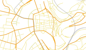
OME2 high-value large-scale pan European prototype data for Luxembourg.
Available via www.mapsforeurope.org, the dataset provides 1: 10 000 scale authoritative administrative boundary and transport data for Belgium, France and The Netherlands. It is the first to be created using the new production process, developed by OME2 consortium member, National Institute of Geographic and Forest Information (IGN France), to deliver edge-matched official geospatial information from multiple national sources.
In addition to IGN France, the project partners comprise: EuroGeographics, the not-for-profit association for Europe’s National Mapping, Cadastral and Land Registration Authorities; National Geographic Institute, Belgium; Hellenic Cadastre; General Directorate for the Cadastre, Spain; and Cadastre, Land Registry and Mapping Agency, The Netherlands.

Coverage of the OME2 high-value large-scale pan European prototype.
Victoria Persson, Project Manager – Data Access and Integration, EuroGeographics said: “We are delighted to announce that the OME2 high-value large-scale pan European prototype now covers Luxembourg and Switzerland, in addition to Belgium, France and The Netherlands. By the end of 2025, it is expected to cover 10 countries with three key themes identified by users and defined as high value by the European Commission – administrative boundaries, transport and hydrography.”
“OME2 is already demonstrating how authoritative large-scale high-value data can be combined to create pan-European harmonised edge-matched datasets to meet demand for geospatial information in all common data spaces of the European Strategy for Data. Its focus on useability, as well as accessibility, will provide a foundation for future pan-European high-value data aligned with key EU Policy objectives and UN core geospatial data recommendations.”
The OME2 project, which is co-funded by the European Union, is also enhancing the five existing Open Maps For Europe datasets. The most recent updates include new releases of the Open Gazetteer and Pan-European Imagery.
The Open Gazetteer provides authoritative geographical names as maintained in the source data from the National Mapping, Cadastral and Land Registration Authorities. It can be used for any reference or information purpose and is updated annually. Germany’s Federal Agency for Cartography and Geodesy (BKG) is the production manager.
BKG is also production manager and product owner of the OME pan-European Imagery service which it makes available through the Open Maps For Europe interface. This processed mosaic with a 10-metre resolution, created from European Union´s Earth observation programme Copernicus (Sentinel-2, L1C-L2A), and can be used as a reference for mapping and visualisation.
EuroGeographics is an international not-for-profit organisation (AISBL/ IVZW under Belgian Law. BCE registration: 833 607 112) and the membership association for the European National Mapping, Cadastral and Land Registry Authorities.
The OME2 project is co-funded by the European Union. It is being delivered by a consortium comprising: EuroGeographics, the not-for-profit membership association for Europe’s National Mapping, Cadastral and Land Registration Authorities; National Geographic Institute, Belgium; National Institute of Geographic and Forest Information, France; Hellenic Cadastre; General Directorate for the Cadastre, Spain; and Cadastre, Land Registry and Mapping Agency, The Netherlands.
Views and opinions expressed are however those of the author only and do not necessarily reflect those of the European Union or European Commission. Neither the European Union nor the European Commission can be held responsible for them.
![]()
We’ve issued our last Messenger of 2024.
Parcels and buildings as well as spatial data from the Address Register have proved a hit with users since the opening of high-value datasets in Lithuania.
Published by the State Enterprise Centre of Registers, the high-value datasets have been opened for re-use and are believed to be of particular importance for the development of value-added services.
“The first datasets were opened by the Centre of Registers five years ago and, in the meantime, data from all the registers and information systems we administer have been opened to the public. With this opening of high-value datasets, we are implementing the objectives set out in the Open Data Strategy of the Centre of Registers and the provisions of the European Union directive, while contributing to the development of digital innovations and advanced services,” says Adrijus Jusas, Director General of the Centre of Registers.
The Centre of Registers opened its first datasets to the public in 2019 attracting nearly 65,000 unique with a total of almost 2.2 million downloads. In 2024, a substantial increase in use was reported with as many downloads as in the period 2019 to 2023.
Currently, everyone can use the data of the Real Property Register, the Register of Legal Entities, the Address Register, the Population Register, the Information System of Legal Entities Participants, the Register of Contracts and Restrictions on Rights, the Information System of Licenses, the Information System of Lists of the Members of Political Parties, and the e-Prescription subsystem free of charge. Data from the Address Register, the Register of Legal Entities and the Real Property Register attract the greatest interest of users.

Please note that the office will close from 23 December and reopen on 6 January 2025.
EuroGeographics is proud to represent the European National Mapping, Cadastral and Land Registry Authorities (NMCAs). The past year has been incredibly successful for EuroGeographics and its members as together we continue to demonstrate not only what can be achieved through Europe-wide cooperation, but also the benefits of integrating pan-European high-value data into European and global infrastructures.
Read about the Highlights, including the Open Maps For Europe 2 (OME2) Project, which is co-funded by the European Union.